
Fire destroyed more than 1.3% of Cyprus territory
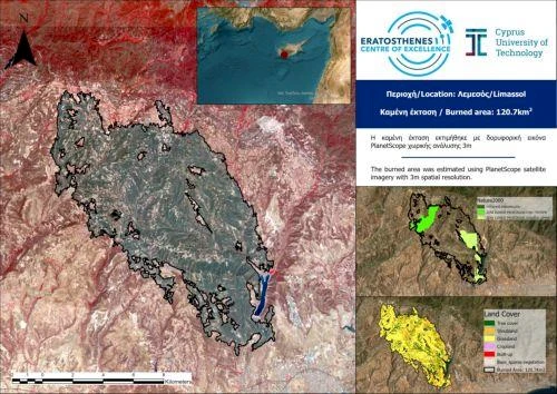
The forest fire that broke out on July 23 in the mountainous areas of Limassol covered more than 120 square kilometers — about 1.3% of Cyprus’s total area. According to the Eratosthenes Remote Sensing Center, the tragedy has become one of the largest environmental disasters on the island in recent decades.
Satellite data analysis (PlanetScope, July 26) shows that the burned area consisted mainly of grass cover (51%), shrubs (31%), and forests (15.5%). Around 1.1% of the area affected were residential zones. Of particular concern is that about 21% of the affected lands are protected Natura 2000 areas, including the Paramalius River valley, Limnatis valley, and the Cha-Potami region.
The fire spread rapidly due to extreme heat, strong winds, and drought. It swept through villages such as Malia, Vasa Koilaniou, Vouni, Souni, Zanakia, Lofou, and others. Dozens of homes were destroyed, thousands evacuated, and infrastructure damaged. Many areas were left without power and water.
Residents criticized the slow emergency response: although flames were first spotted around 12:20, firefighters arrived nearly an hour later, and aircraft even later. Eyewitnesses said pilots were unfamiliar with the terrain, making water drops ineffective. Locals also claimed the forestry department did not deploy sufficient ground forces.
Smoke covered much of the Limassol district, reducing visibility and air quality. Despite international assistance from Israel, Egypt, and Jordan, the fire was only brought under control after several days.
The authorities declared a state of emergency and began aiding victims. Volunteers, organizations, and communities actively joined recovery efforts. The government pledged compensation and reconstruction, but environmentalists warn that nature recovery could take decades.
Author

Education: Higher legal education (specialization — military law), 2007–2012; Advanced training courses in management and law enforcement (2013–2015). Work Experience: Head of departments for law enforcement and administrative practice (2012–2020) Expert in economic evaluation and…
You may also be interested in:
- More than 500 cases of violence recorded in Cyprus schools during the academic year
- Cyprus and energy prices: Quick fixes or a hidden cost?
- Audit Office: Cases of long-term social benefit payments failing to meet criteria identified in Cyprus
- Paphos banana farmers hope for season recovery after rains
- Geroskipou Municipality mandates landowners to clear plots by April 26
