
Trekking routes of Northern Cyprus
The beautiful nature and diverse relief of the northern part of Cyprus have inevitably led to the emergence of trekking routes of various difficulty levels.
In total, Northern Cyprus has almost 600 kilometers of trails with varying levels of infrastructure. Before each point, you can find an information board with a map, description, and comments.
You won't find any overtly grueling options, but you can go on a hike for a few hours along a beautiful path, or for two weeks with overnight stays in tents under the starry sky.
Multi-day routes in Northern Cyprus
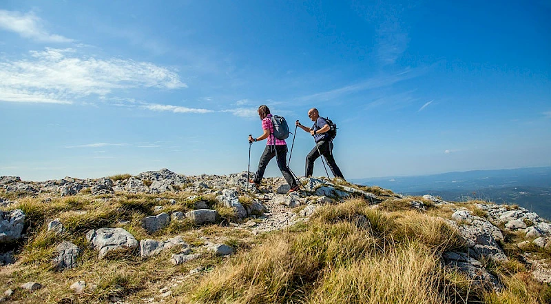
Besparmak Mountain Trail
This is the main hiking route along the Kyrenia Range, which is why it is also called the Kyrenia Mountain Trail. The trail stretches from Cape Kormakitis to the tip of the Karpas Peninsula, and fantastic views will accompany you throughout the entire route.
Various travel companies in Northern Cyprus organize hikes along the trail with different levels of comfort — staying only in tents, or combined with stays in hotels and campsites. There is an option to purchase a tour with vehicle support, so you won't have to carry all your gear in a backpack.
The entire trail takes two weeks to complete, but parts of it are broken down into segments of 5-7 days. You can also hike it independently; the route is marked with green and white signs.
Bellapais — Bogazkoy
This is an eight-hour route that is logical to split into a couple of days to admire the beauty without rushing. The route length is just over 25 kilometers, with a total elevation gain of slightly more than a kilometer.
Short routes for one day
Karmi — St. Hilarion Castle
A popular route from one beautiful location to another. The total elevation gain is 350 meters, designed for 3 hours. You can read about the castle itself in our article.
Zeytinlik — St. Hilarion Castle
Another track to the castle, but starting below the village of Karmi, consequently with a greater elevation gain of 650 meters, and the elevation change will be 900 meters. The trail length is 14 kilometers.
Bellapais Trail
Starts near Bellapais Abbey and includes the surrounding beauty. The length is approximately 11 kilometers with an elevation change of 750 meters.
Bellapais — Buffavento Castle
The 13-kilometer trail starts from the village of Bellapais, with an elevation change of just over 600 meters. It can be combined with a visit to Buffavento Castle, but keep in mind that the round trip takes 4.5 hours plus you will additionally need to climb to the castle itself from the parking lot — we talked about the specifics of this climb in the article about Buffavento.
Alevkaya
Starts at the herbarium in the village of the same name and passes through the ancient Armenian monastery of Sourp Magar. The length is 8 kilometers with an elevation gain of 450 meters.
Esentepe — Antiphonitis
Runs from the village of Esentepe to the Antiphonitis Monastery, which is now a museum. It can be combined with a visit if you time your arrival at the monastery during working hours. The total elevation change is 700 meters, and the length is 13 kilometers.
Yerenkoy
The trail starts near the village of Küçük Erenköy, at the Sinya guesthouse; the length is only 6 kilometers with an elevation change of 350 meters. An easy track with readable yellow markers.
Karsiyaka
Also a short 6-kilometer trail from the village of Karsiyaka. Notable for the ruined Sina Monastery along the way. The elevation change is 400 meters.
Lapta — Baspinar
The track starts in Lapta, at the square of the old Baspinar spring. 9 kilometers and a 900-meter elevation change are complemented by difficult sections; the route cannot be called easy. However, you will encounter abandoned churches along the way.
Arapkoy Circular Track
Starts from the village of Arapköy and mostly goes in a loop. The route length is slightly less than 8 kilometers, and it can be completed in 2.5 — 3 hours depending on fitness level.
Frequently Asked Questions about trekking and activities
What should I take with me on a trekking trip?
Even a short hike along marked routes requires preparation, especially if you are heading out during the hot season. Particular attention should be paid to footwear; if necessary, take trekking poles. Also, bring plenty of water, even if the weather is overcast and not hot.
Are there any apps for hiking in Northern Cyprus?
Yes, but only for Android users: there is a North Cyprus Hiking Trails app available on Google Play, which you can download for free.
What other activities are there in Northern Cyprus?
If you want to see all the routes described above from a bird's eye view, we recommend paragliding — flights take place right over the Kyrenia Range; read about it in our material.
Also, subscribe to our Telegram channel and Instagram, where we talk about unusual places in Northern Cyprus and give useful tips about life on the island.
Author

I am a person who is not afraid to change life when my heart tells me that something greater lies ahead. I am originally from Belarus. I have journeyed from pedagogical and economic education to the financial sector and many years of work in logistics — a world where everything moves, changes,…